 |
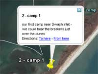
Most folks
have used Google
Earth and if you have you are in for a treat.
Click the image at
left to see a track of Steve's trip. Be sure
to click the push pins for more info about each
location. Let me know what you think.
Chuck |

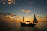
Six days, 97 miles, two sounds, a river and a creek
made for a fantastic sailing trip aboard my John Welsford-designed
Pathfinder “Spartina” in late September.
This trip was a bit different for me. Normally I cruise
single-handed, but this time I brought along Bruce
Hollingsworth, a great friend for over thirty years.
Our friendship goes back to when we worked together
in a scuba diving shop in San Diego back in the 1970s.
We’ve lived on opposite coasts now for over
twenty years but have kept in touch. When I told him
I was building Spartina for some open boat cruising
he asked to join me on a trip. Bruce had not spent
a lot of time sailing, but he had done plenty of backpacking
and wilderness camping. I’ve always thought
of open boat cruising as backpacking on that water
- this trip was an opportunity to combine our skills.
In addition to his experience, Bruce brought along
some excellent safety gear including an EPIRB, waterproof
GPS, safety strobes and a couple of harnesses with
automatic inflation life vests. Combined with my gear
from earlier cruises, we were well prepared.
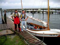
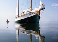
Bruce, left, and Steve at the dock at Harkers
Island Fishing Center
click images to enlarge |
|
Our plan was to circumnavigate a portion of mainland
North Carolina and Cedar Island. What appealed to
me about this trip was the variety of water we would
cover – from narrow channels between sandy islets
to wide open sounds, broad rivers to the long canals
with commercial traffic – each day would be
a little bit different. Plus we would visit a couple
of beautiful waterfront towns along the way.
We put in at Harkers Island just inside of Cape Lookout.
The ramp was at Harker’s Island Fishing Center
which offered a modest hotel, excellent ramp and vehicle
storage all at reasonable prices. I would recommend
it to anybody wanted to cruise in the Cape Lookout
area. We arrived late on a rainy evening, rigged and
loaded the boat and then headed to a nearby seafood
restaurant. Then back to the hotel for some rest and
to go over the charts one last time.
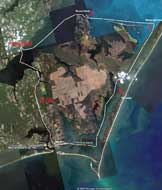 |
Our route up
Core Sound at right, across the bottom of Pamlico
Sound, down the Neuse River to Oriental and
down the ICW to Beaufort and then back to Harkers
Island. Click image for larger view.
Click HERE
for an interactive version (must have Google
Earth) |
We launched in a steady rain and started the first
leg of our trip up Core Sound just inside of the Core
Banks. The weather cleared by mid afternoon and by
evening we anchored at an area called the Swash, so
near to the barrier island we could hear the surf
breaking on the other side of the dunes. The second
day took us the northern end of Core Sound and an
anchorage in three feet of water behind Wainwright
Island. The lightest wind of the trip was on the third
day as we motored across the bottom of Pamlico Sound.
The water was so glassy calm that we stopped miles
out in the sound for an afternoon swim. Later that
afternoon, as the wind picked up, we reach our next
anchorage at Raccoon Island. Day four was a great
reach across the Neuse River to Oriental. We tied
up at the public dock there and stayed at the Oriental
Marina and Inn just yards away. A couple of Coronas
followed by dinner on the waterfront made for a great
evening. Day five we headed back across the Neuse
River and up winding Adams Creek to the Intercostals
Waterway. Twenty five miles later we passed under
the bascule bridge to Beaufort. We were out on the
water thirty minutes before dawn the next morning
on the short run back to Harker’s Island Fishing
Center and tied up at the docks before nine.
It was a fantastic trip that we’ll remember
for a long time. I’m already looking forward
to a spring cruise. With that in mind I would like
to take a moment to look at equipment/techniques to
see what worked well and where we could make some
improvements.
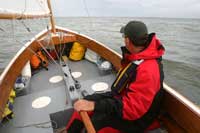
| Bruce at the tiller,
boat fully loaded with gear, food and water for
two – and still a wide open cockpit |
|
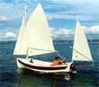
The boat
I’m a real fan of John Welsford’s Pathfinder
design. I built mine as a gaff rigged yawl with a
conventional boom. It is a joy to sail. On this trip
we had two people, boom tent, sleeping bags, three
cameras, two fishing poles plus food and water for
nine days (we carried 50% more than needed as a safety
margin). Even with all that gear on board we had a
wide open cockpit.
Food
I carry a Coleman propane grill with a burner and
a griddle. A typical dinner was sautéed onions
and peppers mixed with chicken breast (from a foil
packet) served with instant mashed potatoes. It was
easy to fix, tasted great and was very filling. Breakfasts
were granola type bars. Lunch was tuna fish salad,
crackers and fruit.
Most of the food was in the water tight areas beneath
the thwart (along with our clothes). Veggies were
stored in a mesh hammock up under the foredeck where
they stayed fresh and dry.
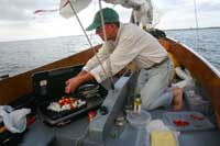 |
Peppers, onions
and chicken on the griddle, mashed potatoes
in the pot |
Boom tent
This is an area where I would like to makes some
improvements. My boom tent is made out of polytarp,
closed at the front end and open at the aft end. During
my spring trip on Chesapeake Bay it was cool and comfortable.
On this trip, with higher temperatures and more humidity,
it was very warm and muggy. Muggy, and yes, buggy.
More mosquitoes than I want to remember. So my plan
it to add mesh covered vents at the forward end and
along the peak, plus put mosquito netting flaps at
the aft end. I won’t completely eliminate mosquitoes
but would like to minimize them. And I think the extra
venting will make things a bit more comfortable.
Sleeping bags
Both of us had good quality synthetic material sleeping
bags. They were comfortable and, once put in their
stuff sacks, took up very little storage space. But
they may have been more than we needed for a late
summer/early fall trip. Towards the end of the trip
we were wearing thermals shirts and pants instead
of sleeping inside of the sleeping bags. One of the
options we talked during the about was using a combination
of thermals and a bivy sac instead of a sleeping bag.
Bivy sacs, at least according to the literature, take
up even less storage space than a sleeping bag, offer
waterproof protection and breathability, and come
with the option of mosquito netting hood that certainly
would have proved useful on this trip.
| Evening at Wainwright
Island |
|
Outboard
One of the decisions we made while planning the trip
was to use the outboard in case of no wind. We had
a schedule to keep, no point in sitting and baking
in the sun when we could be motoring to the next anchorage.
My 3.5 hp two stroke Nissan outboard worked very well.
It kept us moving on day three with virtually no wind,
and it help us navigate the narrow Intracoastal Waterway.
We carried a little over two gallons of gas and that
it more than we needed. Our best estimate was that
we could have covered well over 35 miles with the
fuel on board.
Safety gear
We were extremely well equipped in this area. In
addition to the Coast Guard required equipment, we
had the automatic inflating vest/harnesses, strobes,
cell phones, vhf radio, two gps’s and hypothermia
kits which included extra clothes, thermal blankets
and fire starting equipment.
Things I would like to add
Number one of my list is a boarding ladder. Sometime
this winter I’ll design and build one. We could
climb in to the boat from the water, but it was more
work than I would like. A ladder would be a nice addition.
 |
Swimming on
a calm Pamlico Sound |
For those days with light wind I would like to have
a larger head sail. John Welsford tells me he had
a design for a flat cut radial head gennaker. It will
be at least a few seasons before I can afford one
of these, but some day I would like to have one on
board.
Weather and Planning
I found that inclement weather is not a problem.
We started the trip in a steady rain, and then got
caught by a small thunderstorm the following day.
Our foul weather gear worked very well. In my case,
I had the West Marine jacket and pants, the lowest
cost version they had to offer. They kept me dry and
comfortable. We did not experience high winds on the
trip. We did build two lay days in to the schedule
in case of severe weather, our plan being to anchor
in a protected area and wait it out.
As for planning, I aimed for roughly 16 miles of
travel each day. I found we covered distances quicker
than I had expected. On my next trip I’ll look
at 24 mile days, but 30 miles could be practical.
The next trip
Half the fun of any trip is in the planning. I’ve
been looking over my waterproof chart books of Chesapeake
Bay and North Carolina. There is a lot of territory
out there to be explored. I can see a long weekend
trip in the spring and a longer trip in the fall.
But exactly where, I’m not sure. That will give
me lots to think about this winter.
Steve
More about Pathfinder
|