| Part One - Part Two - Part Three - Part Four - Part Five
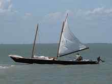
We got up early Tuesday morning, packed our gear and got ready to sail. We pushed the boat off the mud beach. We started to move off under the mainsail alone. When we got in water deep enough I started to lower the centerboard. It was stuck in the up position. We were on a downwind run, so it wasn't critical to get it down. I was more concerned than Bill. Bill was usually the calm one, so we decided to just use the main while I tried to get the centerboard working. I've had the board stick before, but it usually came loose after 15 minutes or so. This time it wouldn't budge. I thought equipment had fouled the lines, but that wasn't the case. Preparing for this event I had made a cover to protect the lines from getting gear placed on top of them. The protective cover was still in place. I figured it was either the black muddy goo from the island or the centerboard cable problem I've read about for the Day Sailer II.
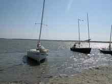
We sailed for a few hours in open water following the channel markers, and then we came to the land cut. We were one of the first boats out that morning, only a few were ahead of us. We sailed that day without the centerboard. The biggest problem we had was clearing sea grass off the rudder blade. Too much sea grass on the blade would cause it to kick up. At least once per hour all day we would clean off sea grass. This is something we did every day; some places weren't as bad though. We made good time getting into Camp 2 around 1 pm. The boats ahead of us had found an alternate camp spot as the original one had very deep mud. The new one had mud, but not as much as Monday night. We beached the boat and set the anchor on shore.
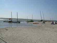
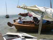
We rested an hour or so including my nap on the bow. We then unloaded the boat so we could careen it and fix the centerboard. With the help of other sailors, who knew better than Bill and me how to careen a boat, we got the boat over on its' side. We had to pry the board out. The centerboard trunk was impacted with mud, oyster shell, and sea grass. The mud was black and very thick. Someone got a water bottle and squirted it in the trunk to wash it out. Took a while but we got the board freed up. The cables and lines were all good. The boat was then righted and reloaded except for our camping gear. I set up my tent, but later had to move it due to incoming tide. It was a very flat beach, others moved as well. The tides down there only fluctuate about one to one and a half feet each day. I think I counted 24 boats at the camp. A few boats camped further down the ditch including some deeper draft boats that couldn't anchor in the channel due to barge traffic.
Wednesday morning we tried for another early start. We got everything ready to go early. We were trying to push the boat off the muddy beach and were having trouble. Some others saw us having a problem and came to help. Trying to push the boat out the rudder got jammed in mud and the rudder head cracked. We pulled off the rudder and got the boat in deeper water. When we put the rudder back on we saw the extent of the crack. It was right below the tiller bolt. Someone had a cordless drill and offered to drill a new hole below the crack. The tiller would sit at an odd angle, but it would work. We got in deep enough water and started our sail down the ditch and the centerboard worked this time.
The wind started out around 10 knots, but started to increase with the heat of the day. The Day Sailer seemed to like the strong winds and we were moving along at 6 to 7 mph according to the GPS. We passed a few boats, some other boats passed us. Some boats pulled over to spoil islands to reduce sail as the winds got stronger. We were at about the middle of the fleet I think. It was a good day sailing even with a damaged rudder. Mid afternoon, the boats ahead of us began looking for our Wednesday night camp location. The beaching area was not marked. When they found a good spot, a call went out on the radio telling the rest of the fleet what channel marker to start turning in towards shore. It was marker 149 as I recall.
We started our turn in towards the shore and spotted a few boats beached already. The water became shallow quickly as we got out of the channel. Using the jib downhaul we got the jib down and secured it. We could see bottom in places. I had the centerboard ready to be pulled up in case we bumped bottom. As we approached the shore we turned into the wind and dropped the mainsail and pulled up the centerboard. Someone from one of the other boats helped us pull the boat to shore. Before we got too shallow, we pulled off the rudder before beaching to reduce the chance of anymore rudder damage. Most of our camp areas had some very shallow water, although there was water deep enough for keel boats to anchor further off the beach.
Our third camp was the best yet, Only 4 to 6 inches of mud mixed with sand. Of course I found my napping place on the bow of the boat. Bill tried to wash his clothes some and visited with the other sailors. We did get some calls on the VHF radio that some boats were having trouble. Chuck Leinweber, who is the event organizer, went back out to assist boats with problems. From what I heard some sails were blown out and there was other damage due to the high winds.
Thursday was the day we were going to cross Corpus Christi Bay.
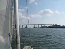
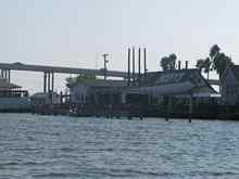
Wind forecasts were for stronger winds than the day before. We started out behind a few other boats that were more familiar with the area than we were, so we followed them until we picked up the line of marker buoys. A short while later we saw the John F. Kennedy causeway bridge we had to pass under before entering the bay. Just before the bridge are a couple of restaurants, Doc's and Snoopy's. Some of the boats where stopping at Snoopy's for breakfast or lunch. We thought about it, but decided that with the wind increasing in strength, we should press on ahead. Many of the boats behind us did stop. A couple boats ahead of us also continued on.
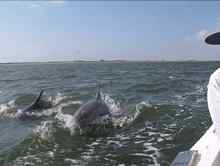
We passed under the bridge and into a channel leading to the bay. On each side of us there were slightly submerged mud banks with birds walking along them. Bill tried to convince me that the water really was deep, and that the birds had really long legs. Dolphins were surfacing alongside the boat. Sometimes they were close enough to touch. We passed part of the fleet, a Bolger Folding Schooner, which had camped the night before closer to the bay. They were beached on a spoil island and the crew was out exploring from what we could see. The Folding Schooner is a 31-foot boat with about a 5-foot beam. When on the trailer, the boat is actually folded in half onto itself.
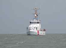
The wind was increasing as we entered the bay. We followed the markers for a while, and then made a slight turn to the east to follow the waypoints I had loaded into the GPS. The course that was in the GPS would allow us to follow a coarse closer to the Padre Island side of the bay and reduce the size of the waves. It was also a shorter route for us to take to our camp site. We would have to navigate thru some shallow areas, but it proved not to be a problem. We saw no other boats from the fleet. With the high winds there were very few boats out on the bay. The only other vessel we saw out there was a Coast Guard cutter anchored. I assume they were out there because they knew a bunch of small sailboats would be crossing the bay.
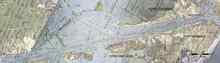
We finally got to Sting Ray Hole and navigated the channel to reach Corpus Christi Channel which would take us pass the ferries at Port Aransas. Texas Highway
361 is cut by the channel. Ferries are provided by the state as a means of crossing the channel. The ferries are free and run 24 hours a day since this is a state highway. We had to sail east up the channel and then turn north into Lydia Ann Channel. There was another shorter way to the camp, but it was not an option for us as it required passing under a low bridge. I believe the bridge clearance was about 8-feet. We sailed up the Corpus Christi Channel in high winds and a lot of choppy waves. The few power boats we saw where having trouble as well. As we made our approach to the ferry crossing we saw they were operating six ferries that day. We had right of way since we were under sail and we had heard that they would try not to run over us, but we wanted to get through as fast as possible. As we got near the crossing, three ferries moved out from shore, two from one side and one from the other side. We felt like it was a game and we were the ball. We got through and made our turn to the north up Lydia Ann Channel. About a mile up the channel we encountered a barge "parking" in the middle of the channel. We maneuvered around it and continued on towards camp. We got to the end of the channel and made a turn to the west and a short time later we saw two of the other boats at the camp location.
This camp was different than previous camps. It was an oyster shell beach, no mud. It was shallow like the others and had some protection from the wind along the shoreline. We brought the boat in near shore and removed the rudder. With the help from the others already there we beached the boat. Soon the rest of the fleet started showing up. At each camp there were fewer boats than the camp before. We heard some boats had gone aground near Corpus Christi Bay; others had dropped out as they felt the conditions were too rough in the bay.
At this camp there seemed to be more activity along the shoreline. There was talk about the days sail and conditions in the bay. Those that stopped at Snoopy's commented on their meal. Some discussion was about the wind forecasts for the next day. The forecast was for increasing wind strength. Also discussed was who was going to try to get to the main camp at Cedar Bayou and who was going to head for the alternate camp at Ayers Dugout. The difficulty for Cedar Bayou is that it is a shallow and narrow channel that heads into the wind. Cedar Bayou ends on the Gulf side of Padre Island with sandy beaches. It is a place inaccessible by vehicles. Deep draft boats probably would be unable to make it. Both camp destinations required navigating thru several oyster reefs. In the expected high winds, running aground was a possibility. A third choice or route was also brought up. Bypass the reefs and sail straight across the bay and join up with another Texas 200 group called the "Geezer Group". This group was only planning to sail two days starting on Friday out of Rockport. We decided to sail across Aransas Bay and camp with the "Geezers". We finally set up our tents for the night, had something to eat and settled in for the night. |