 Custom Search
|
| boat plans |
| canoe/kayak |
| electrical |
| epoxy/supplies |
| fasteners |
| gear |
| gift certificates |
| hardware |
| hatches/deckplates |
| media |
| paint/varnish |
| rope/line |
| rowing/sculling |
| sailmaking |
| sails |
| tools |


| join |
| home |
| indexes |
| classifieds |
| calendar |
| archives |
| about |
| links |
| Join Duckworks Get free newsletter CLICK HERE |
|
|
| OBX 2015 |
by Paul Moffitt
- Philadelphia, Pennsylvania - USA |
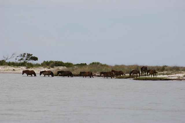
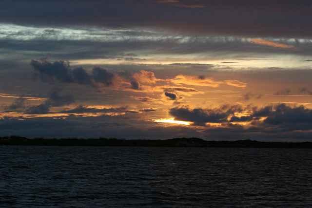
A Preview of the 2015 OBX130 The OBX is kinda a hit and run event. It’s happened four times so far but the last time was 2012. We Moffitt’s are hosting it once again this September 14-18 2015, when the winds are a little kinder and it gets a little cooler in the Outer Banks. This event doesn’t get large crowds, but many of the best sailors in our “scene” have done it. The main reason is not a lot of people have done this event is because it’s 1) far away 2) involves trusting me to tell you where to sail 3) The winds can come from any direction 4) sudden onset of squalls 5) hurricane season 6) either sailing in 6 inches of water along the coast, or navigating the channels. It is inherently a dangerous course, as all of the letters followed by numbers sailing raids. I have done the Texas 200, the Florida 120, and of course the OBX 130. The campsites couldn’t take the numbers of the TX200 or FL120. Reasons to do the event? There are a few I can think of. The Cape Lookout National Seashore is one of the most beautiful places on earth and the nature second to none. Thousands of birds make it their home or migrate through - one of my favorite is the Black Skimmer. You will see and camp with wild horses. Dolphins, turtles, and marlins, oh my! I once got woken up to the sound of horses stampeding down the shore. The camping is all free and you can do it anywhere you want. It’s extremely secluded. The 20 people who are going to go with us are all great sailors and friends. What’s the worse that can Happen? Ask Andy.
I can’t promise this event will happen every year, but I can tell you that you should do it at least once.
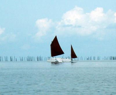
What Kind of Boat is Suggested? Any shallow draft boat will do. I would suggest one with a kick-up rudder and leeboard. The largest draft to successfully navigate this course was about 22”. But it wasn’t easy. I suggest less than 1’. Easy reefing and tested rigging are a must. Storms come quick and furious and sometimes there is nowhere to run. What is the Weather Like? On any given day you will have heavy winds, no winds, light winds, storms, and waterspouts all in the same day. The wind may blow the entire 5 days in the direction you are travelling, or it may be in your teeth for 5 days. These waters are not considered easy to sail in. In general the wind in September blows from the North East about 70% of the time, and the other 30% from the South West. As the course runs from the Northeast to the Southwest, and then reverses the way back you should expect to have downwind runs as well as upwind runs. In my experience storms can come on you quickly and blow real hard for about 20 minutes and then be over. This happens frequently in the afternoons. Expect at least ONE storm to overtake you while sailing this event. Check out the historical records and wind roses at: www.windfinder.com Most of the boats will be home built shallow draft boats with traditional sailing rigs. The fun part is not only seeing the amazing amount of nature along the trip but also travel in the company of like-minded do it yourselfers. Camping on the Cape Lookout National Seashore is free and you don’t even have to register with the Rangers. I like to make the rangers happy, and we might run into some on the trip. Everyone is asked to bring a few trash bags and bring back some trash from this beautiful scenic area. This always makes the rangers happy, and it is the right thing to do.
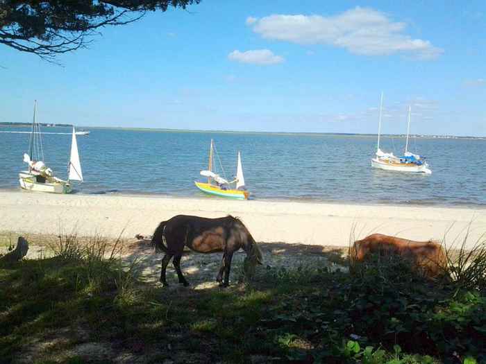
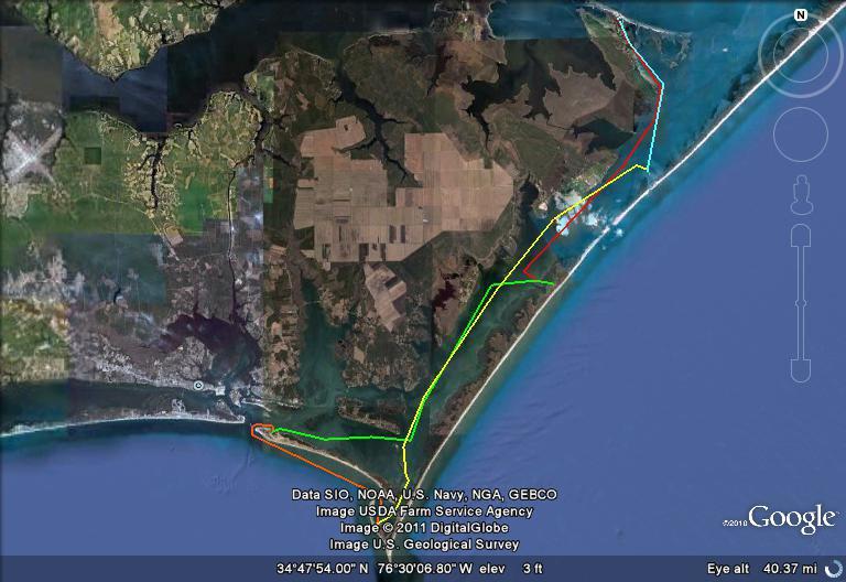
Cedar Island Cedar Island’s nickname is "skeeter island". This is a very appropriate nickname. Mosquitoes seem to rule supreme here. The Driftwood Campground is a friendly little place. New this year is the fact that the motel and restaurant are CLOSED. This means you need to bring food for the start and end of the trip. I will bring hot dogs for the captains meeting. I will try to get some for the last day too. They will let us park our truck and trailers right next door at a closed down convenience store. There are plenty of camping spots and they are first come first serve. You may want to share a camp spot with one of the other participants. There are TWO boat ramps. For a shallow boat you can use the one in the campground. This one I will call the south ramp. It is right in the middle of the campsites. It is shallow and if you have a large boat you will find it really hard to use. There is a little bit of room to tie up your boat. I am expecting it to be very crowded. We will just have to make due I am afraid. But there is also a North boat ramp, which is free. A 30 second drive away from the campgrounds is another boat ramp, which I will call proper and deep. Only problem with it is that it is in the Pamlico Sound so you will have to sail farther the first day to make it to the first campsite. There is a beach right next to the boat ramp that you could anchor off of for the night. There will be a lot less people around there but the waves from the bay will move your boat around. You may want to camp on your boat on the north side of cedar island if you have a larger boat. There used to be a gun club, it is no more. They had a dock, which was destroyed in the last hurricane. It was still usable the last time we were there but it is said to be gone with the tide. There is a small beach right in front. There is also a trail over to the Atlantic side. My brother says there may be Nutria living in the building. There is plenty of room to camp on land but don’t take off your shoes, there are those sticker things and small cactus everywhere. To reach this place you will have to sail south past the club and then angle up into it at low tide. There are sandbars to the north and east of the club and a small cut from the south east leading to the club at the north east of the cut. Look at the KMZ file (click to download) for some GPS marks. That being said, the hurricane changed things. If it is mid or low tide you will hit some sea grass or sand and have to get out and find a way in to the club. When you leave cedar Island you are always safer if you stick to the south side of the bay before it opens into the channel. Follow the channel marks for deep water. If you are not familiar with the area you will see sticks poking up in long lines ranging out into the channel. You can avoid these by sailing due west until you get past them and then head south or you can sail between them. They are sticks for gill nets to be strung up. I have never seen them in use but that doesn’t mean if you try to sail between them you wont find yourself in trouble. You will also see duck blinds on stilts everywhere. I have actually tied off to one and camped on the water before. If you stick to the clearly marked channel you will have no problems with sandbars. You will probably see me ignoring the channel and sailing wherever I want in a straight line to my destination. I have a very shallow and light boat. Follow my father Bill if you have a deeper draft boat. Shackleford Island The spot I marked for camping is where there is an actual bathroom. This Island has wild horses and you can read about the islands history here. I am going to get there by going south of Harkers Island. You can camp on the land. Amazing spot. One of the coolest spots on earth.
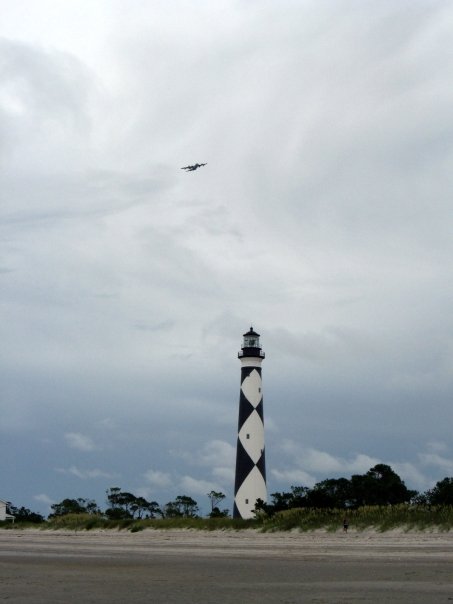
Cape Lookout We will camp in the hook. I have marked a place we camped the last time during a tropical depression and heavy weather. Depending on the waves and weather we may camp there or further up or down the shore. There are two ways to get here. You can go around the outside on the Atlantic side, which is what I plan to do, or you can go back around south of Harkers and follow the ditch into the hook. This is a hard day of sailing either way. If you go out through Beaufort inlet the traffic can be very heavy and if we are fighting the current you can be afraid of not making it out at all. If this turns out to be the case then short tacks close to the west side will get you out. Then simply follow Shackleford into the Hook. When you get close to the hook follow the Buoys until we turn towards the campsite. If you get into trouble and have to land on shackleford getting back off in the surf will be a problem if you haven’t done it before. It is hard and you have to have the right boat to get back out past the breakers. The other way to the Hook is hard to do but for different reasons. The first part is easy, follow the markers back to the east tip of Harkers island. Then you need to properly identify the markers that lead into the Ditch. Any GPS will have them marked for you. Now you need to pass each mark on the correct side, Green on the right, Red on the left, and whatever you do, don’t skip a marker!!!! The ditch is just that. A deep ditch with sand bars on either side covered in 2 inches of water. The Current is FIERCE. Time your attempt with the tide in mind or you won’t make it. Also be very weary of motorboats in this area. Luckily we will be doing this not on the weekend so it won’t be so bad. Also, it will be past labor day so a lot less bad boaters will be around. But no one is going to slow down or avoid you. Be ready for very rude motor heads. Scared? Good. Why go through all that to get to cape lookout? Because it is the “graveyard of the Atlantic.” There are wrecks everywhere and you can find them at low tide. Bring snorkel gear and a wreck map if you are into that. There is a cool museum next to the Light House. Sunset is spectacular. There is a boardwalk over to the Atlantic where you will find the beach faces East and enormous breakers pound the beach. On Wednesdays they have guided tours to the top of the light house. There is an island called Dump Island that is a private island owned by a real cool guy my brother Sean met this summer. He doesn’t want campers on the island but since the hurricane last summer the south inlet has opened back up. There is small island there where we will camp and/or anchor off for the night. This is the longest day of sailing and if the wind is in our teeth we may have to stop earlier at the Gun Club or another campsite I know of. Return to Cedar Island If we made it all the way to the spoil island then the last day will only be a few hours of sailing before we get back to camp. If we had to stop because of bad wind then it could take all day. Hopefully, we can have a final BBQ and a good sleep before we all leave the next morning. How Do I Participate? The simple answer is show up for the captain's meeting with a boat. If you are on facebook then join the OBX130 group. If you don’t do the whole facebook time suck thing then you can email me directly with any questions you may have: thatmoffitt at gmail.com
Here is a map of the possible course for 2015. I hold the right to change the course as weather and winds dictate. Red is Day one heading south to The Abandoned Gun Club. Day Two is Green to the backside of Shackleforde Island with wild horses. Day three is yellow to Cape Lookout inside the Bight and a visit to the museum/ lighthouse/ Atlantic. Day Four is to an undisclosed spoil island I will reveal later. We will have to sleep on our boats at this campsite. Then the fifth day is the shortest run back to Cedar Island. The second and fourth days are the longest sails. The second and third day there are two different ways to possibly take. The fifth day is the shortest sail at a mere 10 miles of sailing as the motor boat goes. If you were to motor boat this course it would be 90 miles. Depending on winds it could be a lot more then that sailing. When I picked the name OBX130 I was guessing at the mileage it would take total to sail the course. |
|||||||||||||||||||||||
To comment on Duckworks articles, please visit one of the following:
|


 |