 Custom Search
|
|
| sails |
| plans |
| epoxy |
| rope/line |
| hardware |
| canoe/Kayak |
| sailmaking |
| materials |
| models |
| media |
| tools |
| gear |
 |
 |
| join |
| home |
| indexes |
| classifieds |
| calendar |
| archives |
| about |
| links |
| Join Duckworks Get free newsletter Comment on articles CLICK HERE |
|
|
| Valora's Log |
by David Nichols - Austin, Texas - USA On to Apalachicola and St Joe |
 |
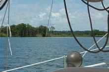
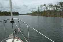
| We had planned to make the 6 to 8 hour run to Apalachicola outside but now the weather was starting to not cooperate. The XM Weather showed lots of red patches with little lighting bolts coming from them and those patches were headed in our direction. This didn't bode well for a run in the open Gulf so I elected to stay in the ICW (Intracoastal Waterway). That way if we got caught we could anchor, deploy the lighting grounding system and ride out the storm. The direction of the storm's movement made the barrier island, St George Island, a lee shore. We wouldn't have enough room to heave to and ride out the storm below deck where we needed to be. So the fuel tank was topped off at the marina and we headed to Apalachicola under Valora's diesel engine. Valora's fuel tank held 25 gallons which gave us a 250 mile range. The verified burn rate for her 18 HP Yanmar is ½ a gallon an hour at 5 knots. So 25 gallons divided by ½ gallon per hour equals 50 hours multiplied by 5 knots equals 250 nautical miles. 250 miles is a long way on the ICW and I had always wanted to do the Great American Loop. The morning of June 23, 2011 found me doing some of the Gulf leg of the GAL; a nice way to start the day. Actually, the day continued to be nice. The storms made land fall either behind us or in front of us. There was lighting but it was never closer than 10 miles or so. We never had to actively dodge any of the storm cells so we made good time. It was early afternoon when we motored into the municipal marina at Apalachicola. The sun was brutally hot but we still decided to walk around the town and I'm very glad we did. Unlike Carrabelle, there is a lot happening in Apalachicola (this may not be a fair statement because we never got any farther than the market in Carrabelle). Apalachicola has a downtown with restaurants, coffee houses, old hotels all with in a few blocks of the marina. Most of the buildings in downtown are old and the city has done a nice job of restoring and using them. The town is a work in progress but what old town on the Gulf Coast isn't? It turns out the town dates from the 1830's and was the third largest port on the Gulf Coast. The Apalachicola River was the main highway for exporting cotton from southern Georgia and Alabama. History is nice but people make the place and everybody we met was very nice. Actually, it wouldn't be a bad place to spend some time, say a winter. There's even a good hurricane hole up the river. There's one more facet to Apalachicola that made it very attractive; the marina was free. It wasn't supposed to be but because the harbor master had left under a dark cloud, management of the marina had been turned over to the police department. Apparently they felt they had more than enough to do so there was no one to pay for the use of the slip. I'm sure this strange arrangement will change; no government likes to leave money on the table but it certainly made our stay more pleasant. Both Gene and I felt it would be unpleasantly hot to spend the night at the marina so, at sunset, we motored out and anchored where there was some wind. We picked a spot in 8 or 9 feet of water several hundred yards from the ICW and set a good scope on the anchor rode but it was not to be. The weather didn't cooperate once more and a couple of hours later we had to pick up and head back to the marina. Certainly we could have stayed and deployed the lighting system but I wanted to be where there were masts that were taller than mine. The run back in the dark wasn't as bad as it might seem because we could backtrack with the Garmin. Without that backtrack the run would have been very scary. We were in shallow water and could have easily gone aground. I did get one lesson from this experience, maybe two. Early on the spotlight that came with Valora died and I replaced it with a battery powered spot rather than a spot that used the ship's power. Of course, as we were searching for the channel markers the batteries faded and died. I managed to grab a small flashlight from below and used it to help find the markers in the dark. Without the spotlight and without backtracking on the GPS we would have been in a hell of a bad spot. With the backtracking it was scary enough for me. Obviously the lesson here is to have the spotlight run off the ship's power and the stand alone spot act as back up. The second lesson might have been to check the XM Weather before we left the marina. West toward St JoeThe section of the ICW between Apalachicola and St Joe is a very pretty stretch of water. There is a great deal to see. The river is wide and deep near the bay with nice stands of timber.
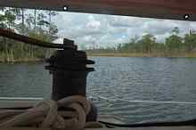
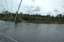
The funny looking things attached to Valora's life lines are solar powered lights that are turned on when we anchor in open water. The lights supplement Valora's normal anchor light. Unlike some solar lights these can be turned off when just running lights are needed. The lights can be found at Lowe's and probably other home centers. I tied them with zip ties.
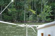
... Lots of Ospreys. The white balls are crab pots and warps that, if you aren't careful, will wrap around your prop in a heart beat leaving you up the creek without a paddle, so to speak. If it hadn't been for the Ospreys we would have had the ICW to ourselves. With Valora's engine chugging along this section had kind of an African Queen feel to it. The narrow river with sub-tropic vegetation right up to the water and large open areas of marsh made it easy to imagine we were not in the Florida Panhandle.
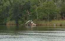
Somewhere before we turned into the land cut to St Joe we came across the bones of an old shrimper. This one had not survived a hurricane.
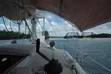
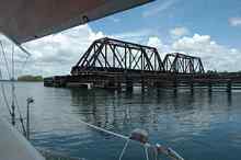
I found this section of the ICW the best. There was a great deal to see and we had it all to ourselves. We didn't pass another boat or see another person once we passed the rail road bridge. The thunder storms were becoming more frequent but they were keeping their distance. This was a trend that would not continue. The nice scenery also stopped as soon as we entered the land cut to St Joe.
David's plans are in the Duckworks Store Click Here for a List of Articles and Columns by David Nichols |