|
Recently, I looked over the navigational charts available
for my area, and was disappointed to find that the area
of most interest to me was only available on a large island-wide
map, without the kind of scale I wanted. Disappointed, I
decided to look around the Web to see if there were any
electronic charts available.
It turns out that the National Oceanic and Atmospheric
Administration, Office
of Coast Survey has a pilot
project to distribute navigational charts in electronic
form. It is currently in the beta stage, with a fairly wide
but incomplete set of about 100 charts available, and by
good luck, my own area is covered. The OCS distributes the
charts as .zip files through a very nice download
management page, where you can check off the different
charts you are interested in, and then they are all bundled
together as one download. If you have a fast and dependable
connection, just check everything you are interested in,
but if you are on dialup, it might be better to download
each chart seperately, since some are rather large. The
charts are distributed with the warning that they are not
to be used for navigation.
The charts are in a format called Electronic Navigational
Charts (ENC), which can be read by several different free
programs. The NOAA has a page that links up to the various
sources for the viewers. Two of them work with Windows
95/98. The other three need Windows 2000 or XP, so I was
unable to evaluate them. We'd be interested in seeing a
review of the Win2K/XP viewers, if anyone out there would
write them up. (Editors Note: I was able to download
and use both programs on an XP machine with no problems.)
The Win98 ENC viewers are called SeeMyDENC, distributed
by SevenCs
GmbH, and dKart Look, distributed by HydroSERVICE.
dKart Look 4.0 is supposed to be a Win2K program, but except
for the print feature, it worked well on my Win98 machine.
Both installs were easy and quick on my machine.
SeeMyDENC
SeeMyDENC handles SENC, S-57 and DENC files. The
NOAA files are in the S-57 format.
It took some time to open the large map of Oahu I was interested
in, as SeeMyDENC spends a lot of time checking
the file for problems, but eventually, it did open and the
level of detail was amazing, with a zoom feature that allows
you to zoom in as deeply as you want.
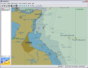
SeeMyDENC
Screen Shot (click to enlarge)
The display can be customized to an incredible degree,
ranging from a simple outline of land masses, a few depth
contours, and some standard navigational features, to full
labelling of all features along with with soundings and
a latitude/longitude grid, with so much information the
map is almost unreadable, and with two choices of symbols,
simplified and traditional. This is where I encountered
my first problem with SeeMyDENC: there was no reference
to explain the meanings of the symbols, though the HTML
help file did note that the symbols used were "according
to the IMO Draft Performance Standards as well as a set
of standard symbols that were designed according to the
International Chart 1," so it shouldn't be too difficult
to round up an outside reference.
Moving around the map is quick and easy, simply put the
cursor at the point where you would like the map to be centered,
hold down the "shift" key, and left click. Then
use the zoom buttons until you are as close as you want
to get.
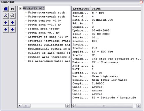
My favorite feature was the notes. Simply left click on
any point on the map, and a set of notes covering navigational
warnings, names of features, soundings and navigational
position. For instance, I clicked on a group of rocks a
few hundred yards offshore:
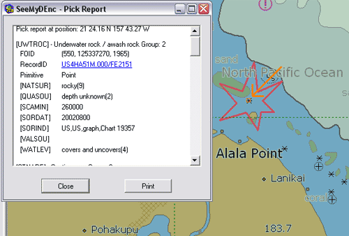
SeeMyDENC
Report
The program will print out your active window, however,
the page setup is not very good, so maps printed out on
8.5x11 are too small to be practical. There is a work-around,
though, since SeeMyDENC will save any map to the clipboard
so it can be imported into an outside graphics program,
where it can be sized, cropped, and printed to suit your
needs. You should also be able to take the file down to
a local print shop and get it printed out in a larger format.
Remember, though, the charts are not meant to be a substitute
for official navigational charts.
SeeMyDENC has one very serious usability issue..
The charts don't have a scale or a compass rose on them,
so the only way to figure distances is by using a known
distance within the map to estimate. Headings are easier,
since the latitude/longitude grid will give you your true
bearings. You'll have to figure magnetic deviation yourself.
The omission of those features may be intentional, though,
since the NOAA repeatedly states that these charts are not
meant for navigation.
dKart Look
dKart Look opened the map file more quickly. Version
3.0 was much more readable than SeeMyDENC, due to some good
choices in screen colors, but Version 4.0 has an irritating
overlay of ovals. However, Version 4.o also has a great
tool, Measurement, under the Files menu, that shows the
distance and bearing between any two points, simply click
on one point then move the cursor to any other point and
the distance and bearing are displayed.
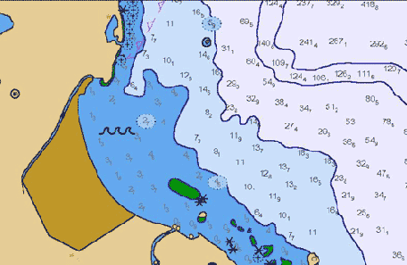
dKart Look V3.0
Other than that, both versions of dKart Look are quite
a bit simpler than SeeMyDENC, and lack a few of
that program's useful features. V3.0 (above) did not have
a print feature. However, that problem can be worked around
easily using Windows shortcut keys, Shift-Print Screen will
save the current screen to the clipboard where it can then
be pasted into an outside graphics program. V4.0's (below)
print features were better than those of SeeMyDENC (except
for the previously mentioned ovals), but apparently were
incompatible with Win98, since they caused Look to crash
on my machine.
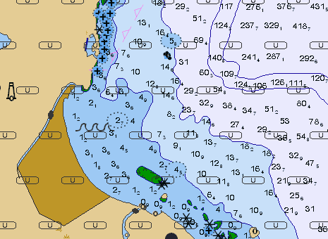
dKart Look V4.0
Navigating around in dKart Look was simple, just left-click,
and that point becomes the new center of the display, then
zoom in or out using the toolbar buttons.
What was most notable thing missing in both versions was
the lack of landmark names. Some of them could be retrieved
by right-clicking on the area of interest, but there were
many where names that showed in SeeMyDENC could
not be seen in dKart Look. One area where dKart
was definitely superior was in the formatting of the notes.
Both programs pop up a window with navigational notes when
you right-click an area, but the formatting of dKart Look
was much more readable, with less redundancy and garbage
characters.
dKart Look
Report
The View menu allows you to choose layers of data, to customize
the map to whatever degree you find useful, allowing you
to choose whether or not to display items like constructions,
soundings, navigational aids or special areas.
These electronic charts are a great companion for the simpler
non-mapping GPS units, since you can pull lattitude and
longitude of waypoints off the charts in both viewers simply
by moving the cursor over the chart.
Despite the warnings that these charts are not to be used
for navigation, you can learn a lot about your local cruising
grounds from them, and can print out details to supplement
your official charts, especially if the area you are interested
in is not commercially navigated and low-scale maps aren't
available. For instance, I learned that there were several
bouys a few miles off-shore of the launch ramp I use, so
now I have a voyage out to see them on my list of adventures,
and thanks to dKart Look, I have both the compass heading
and an accurate distance to work with.
|